
Two world-class belts.
A district-scale silver story next to a global top-5 mine in Bolivia, and a drill-ready copper-gold project in a tier-one Canadian jurisdiction.
Explore the ground.
Metalero’s project claims and the surrounding mining district, live via MiningHub — zoom and pan to explore the tenements.
San Cristobal East & South
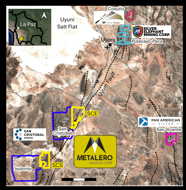
Positioned adjacent to the world-class San Cristobal Mine, Metalero’s district-scale Bolivia projects target large-scale silver systems along the highly prospective Uyuni Fault System — in one of South America’s most underexplored mineral belts.
The target
The San Cristobal East (SCE) and San Cristobal South (SCS) projects comprise a district-scale ~230 km² land package in southwestern Bolivia, directly adjacent to the world-class San Cristobal Silver-Lead-Zinc Mine and the Isidorito silver prospect. They lie along the regionally significant Uyuni Fault System and overlie the same prospective geology and large-scale structural corridors associated with the San Cristobal, Pulacayo-Paca, and Cosuno silver systems.
Metalero entered Bolivia as an early mover into one of South America’s most underexplored mineral jurisdictions, where approximately 60% of the country remains unmapped or underexplored.
Exploration plan
Initial exploration is focused on defining large-scale silver systems ahead of a maiden drill program.
Geological mapping
District-scale mapping across the SCE and SCS concessions.
Geochemistry
Detailed rock and soil sampling to trace mineralised systems.
Geophysics
Ground and airborne surveys to define regional structures and generate drill targets from conductivity, chargeability and magnetic anomalies.
Alteration targeting
Identifying zones of hydrothermal alteration and sulphide enrichment.
Benson Copper-Gold
Benson is drill-ready and located within a prolific copper-gold belt, with multiple large-scale targets showing analogues to major producing deposits.
Project area
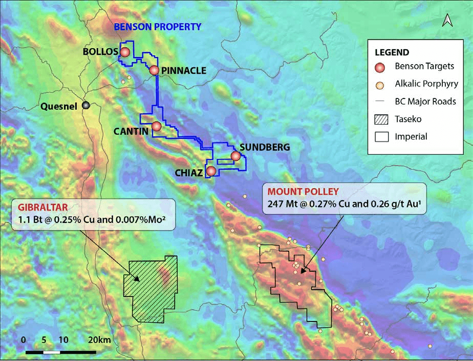
Highly analogous to the Mt. Polley and Mt. Milligan deposits, Benson is underlain by the same Triassic-Jurassic intrusive suites and large-scale fluid-conduit structures. The property covers 173 km² of road-accessible terrain just 15 km east of Quesnel, British Columbia — in the heart of the Quesnel porphyry belt and 30 km northwest of Mt. Polley.
Major mining companies are already active in the area, with Fortescue recently staking over 4,000 km².
Drilling & targets
Multiple Cu-Au targets have been identified through AI-assisted targeting by Geoscience BC, with well-defined correlations between magnetic anomalies, mapped structures and geochemical signatures.
- Historic drill intercepts up to 1.4 g/t Au over 11 m
- Gossanous intrusives with porphyry-style alteration
- Broad magnetic & geochemical anomalies over multiple km-long trends
- Historical drilling confirmed gold over wide intervals; copper assays were historically limited or absent
- Permitting underway; five high-priority zones to be tested across multiple phases
Cantin
9 km anomaly- 9 km-long geophysical anomaly
- Gossanous intrusive rocks and coincident soil anomalies
- Epithermal- and skarn-type mineralisation drilled historically, associated with porphyry deposits
- Historical logs recorded copper minerals and porphyry-style alteration, but copper analyses were rare
Sundberg
4.5 km anomaly- 4.5 km-long geophysical anomaly
- Copper and gold in soil anomaly down-ice to the northwest
- Altered and mineralised volcanic rocks identified