Metalero’s Projects
Benson Project
Benson is drill-ready and located within a prolific copper-gold belt, with multiple large-scale targets showing analogues to major producing deposits.
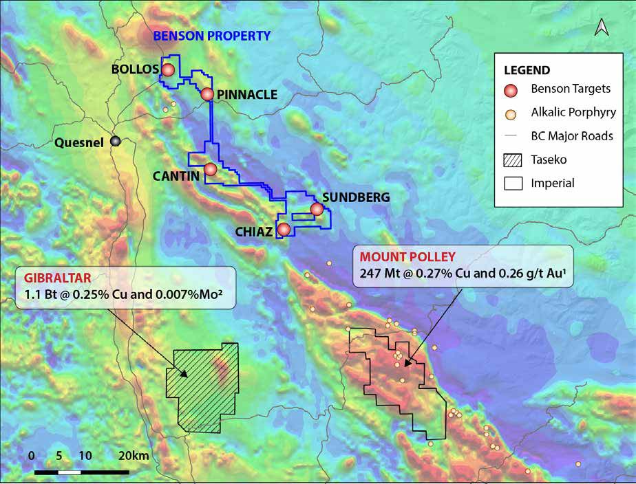
Highly analogous to Mt. Polley and Mt. Milligan deposits, the Benson project is underlain by the same Triassic-Jurassic intrusive suites and large-scale fluid-conduit structures. The property includes 166 km² of road-accessible terrain just 15 km east of Quesnel, British Columbia, in the heart of the Quesnel porphyry belt.
Major mining companies are already active in the area, with Fortescue recently staking over 4,000 km². Historical data and modern geophysics support the presence of multiple Cu-Au targets, making this a compelling underexplored discovery opportunity
Located along trend from Mt. Polley and only 30 km northwest of it, the Benson property contains several high-potential zones identified through AI-assisted targeting by Geoscience BC. The property features:
-
Gossanous intrusives with porphyry-style alteration
-
Historic drill intercepts up to 1.4 g/t Au over 11m
-
Broad-scale magnetic and geochemical anomalies over multiple km-long trends
-
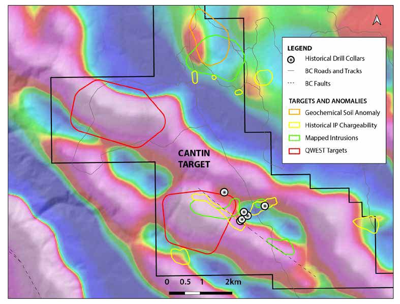
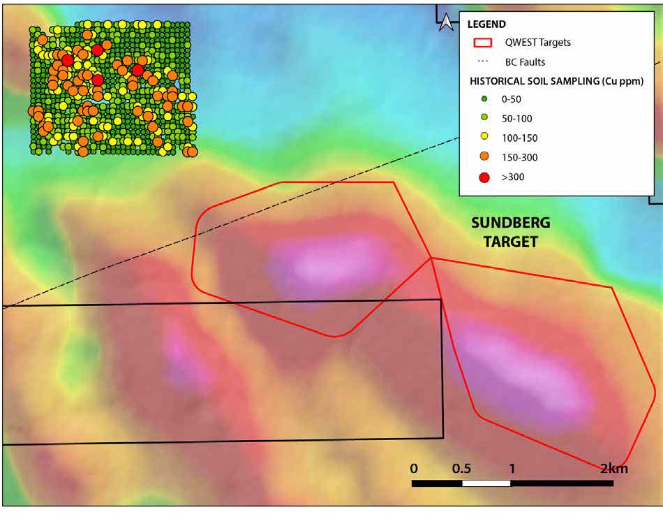
Priority areas include Cantin (9 km anomaly) and Sundberg (4.5 km anomaly)
These targets are analogous to mineralization types typically found at large porphyry systems in the region.
6Well-defined correlations between magnetic anomalies, mapped structures, and geochemical signatures define the drill targets. Historical drilling has already confirmed gold values over wide intervals, but copper assays were historically limited or absent.
-
Permitting is underway
-
Initial drill program is expected to begin in Spring 2026
-
Five high-priority zones will be tested across multiple phases
The strong potential for a Cu-Au porphyry discovery beneath the shallow cover makes Benson one of the most prospective, underexplored properties in the belt.
Projects Held for Sale
ROBERTS CREEK
Stratigraphic & Structural Controls Similar to McEwan’s Gold Bar Mine:
819k oz Au measured & indicated, 201k oz Au inferred
- Located in the Gold Bar district along the Battle Mountain Eureka Trend
- Magnetic and Gravity anomalies coincide with projected structures and soil sample anomalies beneath the alluvium cover
- Drill ready with well-defined targets, drilling permits in progress
COBRE
Analogous toLong Canyon Mine:
Carlin Type Gold deposit 170k Attributable oz Au
-
Large land package located within the Long Canyon Trend with excellent infrastructure
-
Magnetic anomalies coincide with structures projected from the range, Jasperiod outcrop and possible intrusive dykes & swarms that would be sources of mineralization similar to Long Canyon
-
2021 field work includes alteration mapping and planning a drill program
IVANHOE WEST
Analogous to Hollister Mine that produced >450k oz Au and >2.5 Moz Ag
-
Situated along the Carlin Trend related to Miocene epithermal high grade gold mineralization
-
Surface structures and alteration indicate a low temperature epithermal deposit
-
Current field work includes a detailed soil surface sampling program and a Ground Magnetic survey to identify drill targets
GOLDRUN
Analogous to Newmont’s Phoenix Cu-Au deposit 241k Attributable oz of Au and 32M Attributable pounds of Cu
-
Located along an extension of Getchell Trend targeting Eocene Au-Cu mineralization
-
Ground Magnetic and surface sample anomalies indicate a Carlin-Type gold deposit
-
Rock samples taken from historic mining on project yield up to 4 g/ton Au 29g/ton Ag
Projects Under Option
Powerline Project
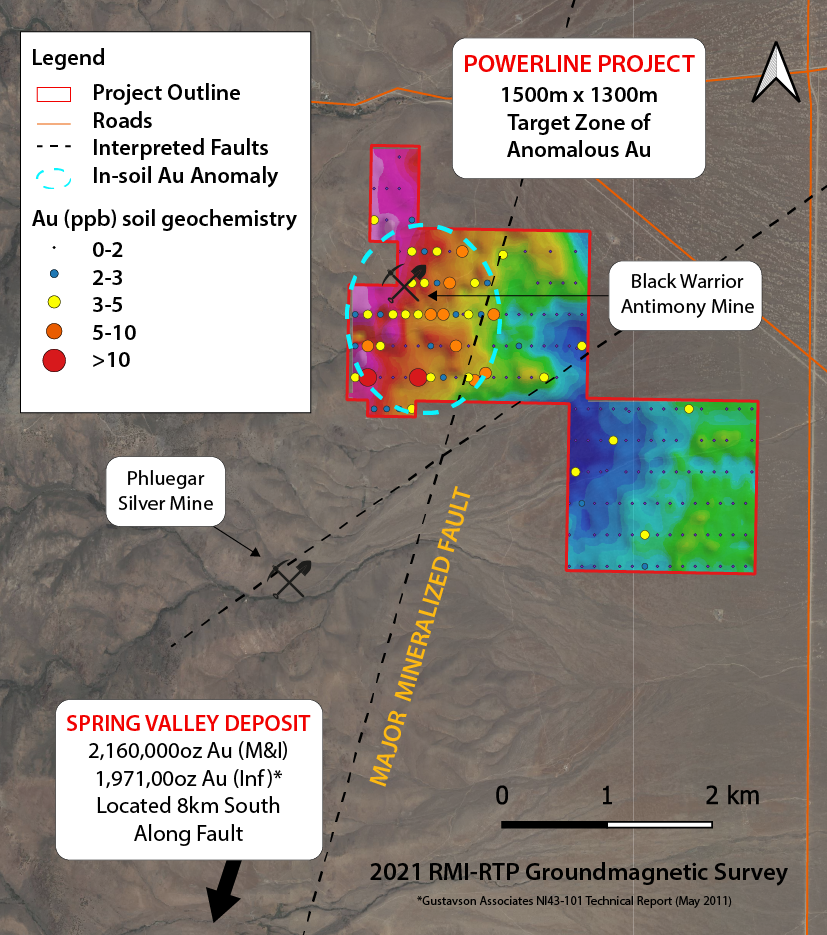
Powerline is drill-ready and situated on-trend with 5 deposits totaling >8 Moz of gold resources.
Highly analogous to the Waterton Spring Valley Deposit sharing similar structural trends and altered lithologies, including Triassic rhyolites, siliciclastics, and carbonates in the Humboldt range. Spring Valley reported a measured and indicated resource of 2,160,000oz Au and inferred resource of 1,971,00oz Au in 20111.
References
- Gustavson Associates 43-101 (May 2011)
The Powerline project is located 8 kilometers northeast of the Spring Valley gold deposit along a southwest extension of the Getchell Trend, a major northeast structural trend of deposits containing 19.4 Moz Au produced and 42.5 Moz Au endowment.2
Silver and antimony mines on the range formed in a northwest-trending corridor project onto the pediment to intersect the main north-northeast fault through the major deposits. These elements are common pathfinders to gold mineralization, often peripheral to a central hydrothermal hot spot in large Nevada gold deposits.
References
2. Total estimated gold endowment based on Muntean (PDAC, 2020)
Well-defined correlations between mapped structures, geochemical anomalies, and magnetic anomalies define drill targets and strong potential for an epithermal deposit below the pediment. Drill permitting for the Powerline project is in progress.
Cantin Target
- 9 km long geophysical anomaly
- Gossanous intrusive rocks and soil anomalies in the area
- Epithermal- and skarn-type mineralization drilled historically – both of these are associated with porphyry deposits
- Historical drill logs recorded copper minerals, porphyry-style alteration but copper analyses were rare
Sundberg Target
- 4.5 km long geophysical anomaly
- Copper and gold in soil anomaly down-ice to the northwest
- Altered and mineralized volcanic rocks identified
Grayson Project
Highly analogous to the Relief Canyon Mine 834,200 oz Au
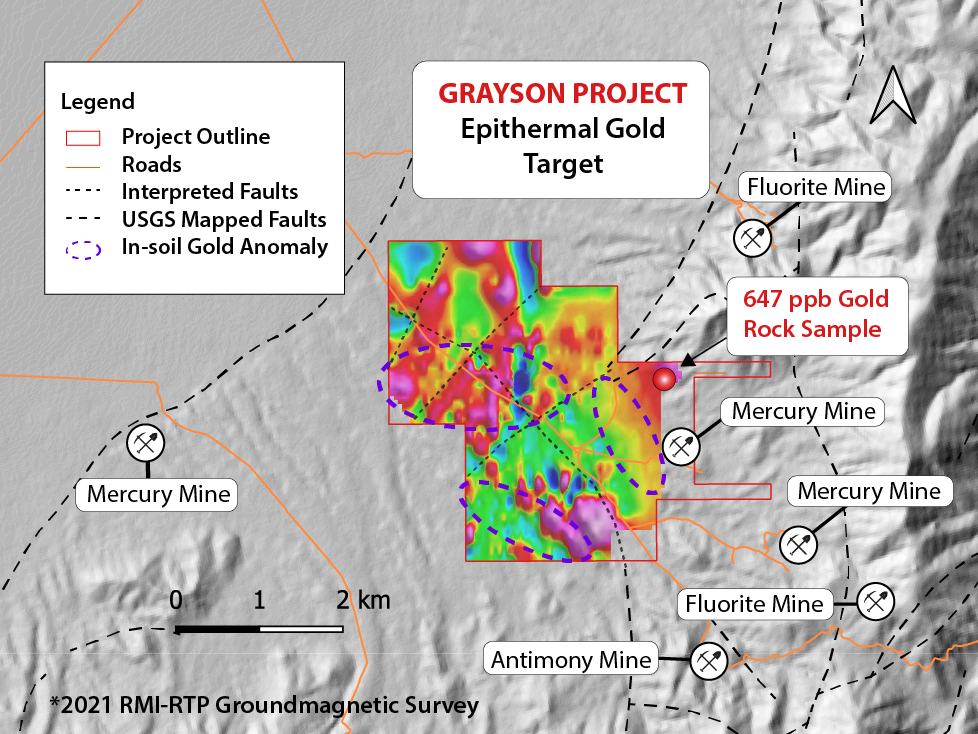
The Grayson Project is a Miocene Epithermal Target with similar stratigraphic and structural controls as those controlling mineralization at the Relief Canyon Mine, 26 km northwest and along strike of the Luning-Fencemaker thrust fault system. Relief Canyon reported a resource of 789,000 oz of gold (measured-indicated) and 45,200 oz of gold (inferred) in 2018*
References
*Technical Report and Feasibility Study for the Relief Canyon Project, Pershing County, Nevada, USA. Pershing Gold Corporation. July 6, 2018.
The road accessible Grayson Project located in alluvial/volcanic covered pediment close to numerous past and presently producing mines including Relief Canyon, Coeur-Rochester Mine and Spring Valley Canyon Mine in the Pershing County, Nevada, USA.
Antimony, mercury, and fluorite mines are present within the range within and surrounding the Grayson Property, these are common gold pathfinders located on the peripheries of large deposits.
Well-defined correlations between mapped structures, geochemical data and magnetic anomalies define drill targets on the Grayson Property. Drill permitting for the Grayson project is in progress.
